Due to a poor weather forecast and a decidedly unstable snowpack in Jotunheimen, the plans which Bjarte and I had of heading down there for a ski traverse were foiled. Late last week we made a quick decision to change our focus to some other majestic mountains just a short drive to the north; the Lyngen Alps.
We had a week off work and after briefly discussing options for simply camping out doing multiple day trips, the idea of attempting a traverse of the entire peninsula came up. Its been done several times before in a variety of different ways and following a number of different routes. The possibilities really are endless; you could spend several weeks travelling along the peninsula skiing loads of peaks along the way, or you could stick to the valleys and coastline if you wanted. One thing worth noting about Lyngen however, is how complex much of the alpine terrain is; traversing ridges and peaks in this area often requires a lot of challenging and technical alpine climbing, which means carrying the rope and all protection that is required. Being averse to carrying monster packs and loads of luxurious but extraneous equipment, and not really knowing that much about the Lyngen Alps, we opted to ski a route which is pretty standard, with some good skiing, but nothing technically demanding and to do it in a reasonably efficient manner. There was never any goal of setting a fast time or anything like that, we were mainly excited to explore some new mountains and familiarise ourself with the place.
I asked around and got some great route beta from people who were more familiar with Lyngen (a big thanks to everyone who shared tips- you know who you are!) and we ended up planning on following
the same route as Espen Nordahl (the fellow behind
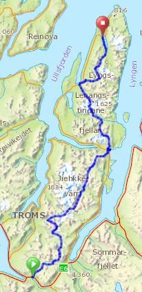
this great book) had skied two weeks prior. In reality we ended up making a few changes due to lack of snow in certains areas, and a desire to checkout some other lines. The route we actually skied looked like this:
 |
| To see the route in detail click here |
Note that we didn't actually finish our tour at the northen tip of the peninsula, we decided to stop 11 km short, due to a lack of snow and the fact that we were pretty sick of walking in soggy ski boots by that point. But I'm getting ahead of myself....
The week prior to our traverse had been defined by the arrival of warm spring temperatures, which led to a significant avalanche cycle and a lot of snow melting in a very short space of time. With warm day time temps forecasted, we knew that early starts were going to be vital to move efficiently whilst the snow was firm and also to avoid the avalanche hazard which was greatest in the heat of the afternoon. So we started out at 2am from Nordkjosbotn after a few hours of sleep by the car.
Conditions were pretty good owing to a decent re-freeze overnight and we had a pleasant tour over to Langdalen.
 |
| Bjarte in Lysvassdalen early on day 1. |
 |
| Bjarte on the first proper descent towards Kjeldalen, early on day 1. |
It was about 6am when we reached Langdalen and it felt like time for a cup of coffee so we had a quick break and I gave my ski boots a good wash when I broke through some rotten snow whilst filling water bottles in a small stream.
We continued up towards Guhkegaisa (Langdalstindene on the map) and the gentle glaciers to the east which we skinned up to reach the pass to the next drainage. On the way we got a decent overview of all the avalanches which had released a few days prior.
 |
| Bjarte with point 1404 looming in the background and a bunch of debris from recent avalanches. |
 |
| Bjarte making his way across some debris below point 1214. |
 |
| Looking south from near point 1214. Photo by Bjarte |
We reached the small notch which gave us an entry point onto the glacier which leads down towards Ellendalen, the short north facing couloir was very icy and studded with a few rocks but looks like it would ski brilliantly in different snow conditions.
 |
| Skiing into the short couloir from the notch due east of Guhkegaisa. Photo by Bjarte. |
We reached Ellendalen around 10 o'clock in the morning. It was tempting to continue skiing, we were feeling good and it was still early in the day. But with rapidly increasing temps, knowing that the next suitable campsite was over 15km away and that the snow would soon be an isothermic slurry we decided to stick with our plan of camping here, and enjoyed a lazy day/afternoon of reading and drinking soup before going to bed around 8 o'clock.
 |
| Campsite in Ellendalen for the first night. |
We woke at 2:15 the next morning and after a quick coffee and breaking camp were skinning by 2:40. The route went up the valley to Steindalsbreen, in the early morning light the mountains were looking pretty damn beautiful.
 |
| Looking back down Ellendalen early on day 2. Photo by Bjarte |
 |
| Stunning early morning light at the edge of Steindalsbreeen. |
 |
| The glacial plateau of Steindalsbreen. |
A short ski and a gentle skin brought us to the pass just east of Nallangaisi, from which we enjoyed a fast ski down Veidalen, with a good a crust meaning we could skate and double pole the flat sections.
 |
| Bjarte in the upper section of Veidalen. |
We reached Lyngsdalen around 5:30 and decided to stop for breakfast and coffee in the sun. Then a short bootpack up to Bredalen and a gentle ski down to Kvalvikdalen. It was only a little after 8am, but the snow was already getting alarmingly warm so we opted to hike up a shoulder of scree to reach Goalsevarri.
 |
| Bjarte with Kvalvikdalstinden in the background. |
 |
| I think Bjarte took this photo when we were headed up Goalsevarri, but I could be wrong... |
 |
| A bit of scree hiking up to Goalsevarri made for a nice change to skinning. Photo by Bjarte |
From the pass near point 1094 we skied down to Gjerdedalen and on to Lyngseidet, passing a few people setting out on ski tours on the final part of the descent it felt strange again to be finished for the day when other people were just starting out. We reached Lyngseidet around 11am and bought a pile of food from the supermarket which we enjoyed as a picnic on the balcony at the
Magic Mountain Lodge.
Even though we'd only had two nights out (including the short bivvy by the car before we started), it was really nice to have a shower and enjoy the luxuries of an afternoon in civilization. As usual the hospitality and welcome provided by Patrik and Henrika was wonderful and much appreciated. We set the alarms for 2am again and settled in to some comfortable beds for the night.
Getting moving the next morning was a mental struggle for me, the sleep deficit from three consecutive days of waking around 2am was starting to take a toll on me. On the hike through town and up to the snow line at 300masl I was feeling drowsy and grumpy, once we started skinning and encountered a long stretch of breakable crust my "grumpiness" morphed into rage for a short period as I skinned along and unpredictably punched through the melt freeze crust into isothermic slop up to my knees. I was pretty disheartened that conditions were already so trying at such an ealy hour of the day and knowing that conditions were only likely to deteriorate even further. But trying to catch up with Bjarte, who is a beast and totally zen about things like breakable crust helped keep my mind off things.
 |
| This is was shitty ski conditions look like. Early on day 3. |
The descent from the pass south of Fastdalstind featured a lot more breakable crust, but strangely, once we reached Russedalen the conditions improved markedly and we were skinning in warm but predictable snow up towards Tafeltinden. We had decided the night before to change our route slightly, and head up the big glacier east of Tvillingstinden. The snow here was kind of rotten and we were both struggling with skins failing due to them being totally saturated from the warm, wet snow. It felt extremely foolhardy to be setting out on this heavily crevassed glacier with out ropes, but we decided to get a closer look before making up our minds.
 |
| Approaching the glacier. We ended up taking a route up the lookers right side (not pictured in its entirety). Photo by Bjarte |
In the end, after a lot of expletives I found an okay route weaving between the crevasses and we reached the upper section of the glacier which is flat and much safer. We ripped our soggy skins at the pass between Store Jægervasstinden and Tafeltinden and skied down Lenangsbreen. This was where we finally got what would generally be described as "quality skiing", with some fun corn beside the blue glacial ice.
 |
| Halfway down Lenangsbreen. Photo by Bjarte |
 |
| Bjarte enjoying some great skiing down Lenangsbreen. |
Down at Blåvatnet we were faced with the decision of following the same route as Espen had, which would require a few kilometres of hiking now that the snow had melted out in the preceding week, or attempting a different route over a pass due SE of Veidalstindan. Given the warm temps and concerns of unstable snow we opted to stick with the safer albeit more arduous option of hiking...
 |
| Bjarte apparently unphased by several kilometres of rock hopping in ski boots. |
We hiked for about 2-3 hours, over rocks, through swamps, over small patches of rotten snow and through some birch forest, then traversed up to Botnfjellet where we were finally able to put our skis back on at 400masl. A short, traversing ski descent in some light rain brought us to Veidalen where we searched for a place to pitch the tent. Being tired we weren't particularly fussy and soon settled on a small, lumpy patch of heather to pitch the tent on. We'd been on the move for about 12 hours.
It should be noted here that I had chosen the tent for the trip based on a weather forecast which was calling for dry weather. The tent (
BD's Firstlight) is nice and light, and offers ample protection from wind and snow but is certainly not waterproof. I knew this from earlier trips and as we cooked up some dinner and the rain battered down I knew we only had about 30 minutes before it would start seeping through. Bjarte, ever the optimist, cheerfully pointed out that atleast it was drier inside the tent than out. Thankfully it cleared about 2 hours later and a light wind even dried things out a little bit. With no room inside the tent for drying gear without it saturating our down bags though, we opted to leave our boot liners, clothes, skins etc. outside the tent and hope they dried a bit through the night.
 |
| View from the tent once the rain had passed. Photo by Bjarte |
The next morning we had a sleep in til 4am and then put our still wet boots back on and started skinning up to the pass NE of Veidalsvatnet. It had been a warm night and the snow hadn't refrozen at all. We skied down to Reindalen in some slush at 5am and veered off our intended route again by skiing down valley a few kms to a gully below Stetinden which we skinned up in more slush to reach another pass into Raudtinddalen. The ski down the valley was slow going on account of the sloppy, rotten snow and once we reached Nordlenangsbotn the impact of the previous weeks warm weather on the snow cover became very clear.
 |
| Coffee and breakfast at the snowline in Nordlenangsbotn with the final northern stretch of the peninsula in the background. Photo by Bjarte |
It appeared there wasn't much snow left on the final northern section of the peninsula, whilst the upper section of Store Galten looked to have a decent cover, the route north from there, which is mainly under 500masl promised to be a mix of rotten snow and hiking over scree and talus. Lacking any other shoes, and not particularly excited by the prospect of having to hike in wet ski boots we opted to hike along the fjord to Nord Lenangen, missing out on the final 10km and the right to say that we skiied "Lyngen på langs". In total we had travelled 115km and 8900 vertical metres. It felt kind of ridiculous to quit with only 15 km and 1800 metres of vert left, but both our feet felt like shit by this point from so many hours in saturated ski boots. And even now; a day later, sitting inside warm and dry I don't really regret the decision. It'll be nice to go back and re-do the entire traverse in the future when the snow cover is a little better and we can ski the entire thing.
 |
| Bjarte's feet: wet, swollen and blistered after 14 hours in soggy ski boots |
We spent the next 8 hours hitch-hiking back to Nordkjosbotn and talking about how much we were looking forward to taking our ski boots off.
 |
| Bjarte and I played "balance the ski pole" to pass time whilst waiting for a lift. |
I've already got a lot of ideas of things I want to do differently next time I do the traverse. A slightly different route, and a slightly different approach and gear choice. I think I'll go for this route:
 |
| To see the route in detail click here |
It was a great trip. Lyngen truly is an AMAZING place, with a lifetimes worth of inspiring mountains. I'm already looking forward to my next trip there!